Monday, May 17, 2010

6: Bloemhof Dam - Lion and Elephant (South Africa/Zimbabwe)


Zimbabwe Pictures Here:
South Africa Pictures Here:

Week 6 Update:

Day 36:
One very long, cold and uncomfortable night in a rented caravan later, we were saddled up and ready to blow the Popsicle stand of De Hoek (Fishing heaven). We did not have a tent to fold away (although that would have been a small price to pay for the comforts of Magurudumu’s roof top palace) and on closer inspection, neither hot nor cold water was available in the rough looking ablutions. A tooth cleaning session had to suffice and we got out of there ASAP!

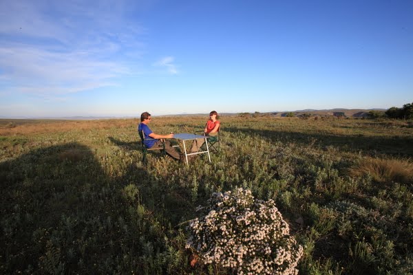
Avoiding road works and toll gates was fairly simple, but a little slower than expected, but we still reached my parent’s local restaurant in Pretoria by lunch time. Mimmos is the only eating establishment you are still able to spend your “Wild Card” points at.

For the Poms: A wild card is like a National Heritage card, granting the holder free access to all National Parks. When you spend money at the parks, you swipe this rewards card and then you are able to spend these rewards in certain places.

As we had just spent a huge amount of time and money in National Parks, we had enough reward points to pay for our lunch, so rather than loosing them, we spoilt ourselves to some restaurant food and fine wine… Bargain!

Our accommodation for our time in Pretoria was at Silver Lakes. This is a security village on a golf course and the house belongs to a family friend who lives in Germany. There is a flat built next to the house and my brother lives there as a “care taker” of sorts. Dr Hasselkus kindly offered us the main house for a few days. This was such a pleasure as the main house in much closer to a 5 star lodge than a normal house.

Day 37, 38, 39, 40, 41:

It all a little bit of a blur, but let me try piece it together:

Friday was admin day! I borrowed by dad’s company scooter to get to the dentist while Catt did career admin. She needed references from lecturers, medical certificates and a whole bunch of other stuff to register her qualification in the UK.

We met back at the house after mid day and then raced off to get the car serviced. In the afternoon I had to inspect my brothers flat after some work had been done on it and just after that we went to Angie and Bertus’s house for a quiet braai. Yeh right! Most of our best friends were there, so it was evident that this was the farewell party we did not have before leaving 37 days before.

Saturday was a complete waste! I blame the small French man and his whiskey pouring skill! I tried to have lunch with my brother and father, but took lunch home in a doggie bag.

Saturday evening we discovered this wonderful thing! It was about 2 x 2 foot in size, shiny, makes pretty pictures and even has sound. I think it’s called a TV. We also found the most comfortable sofa bed right by it, so we didn’t move much after that.

Sunday was a family affair. My dearest mother invited a huge amount of family members and my dearest father had to cook a ton of meat on the fire! Two tables were set and we proceeded in having one of those famous family lunches that starts at 11:00 and ends after dark!

We got home around 18:30 and rediscovered the sofa bed and TV. The great thing about lunches like that is that dinner is simply not necessary! We decided to try and leave by Wednesday…

Monday saw more admin. Mostly ABSA bank, and solving the problems with being able to access our money. This was, to be fair to us; all discussed and sorted a week before day 1. However, for some or other reason beyond our imagination, the bank decided to reset all the accounts and not give us internet access to them. I can see this being a point of ranting before this year is over!

I’ll try a little rant now: ABSA were not able to give us foreign currency because we did not have flight tickets to prove that we are leaving the country. They also wanted to make sure that we are buying the currency with “after tax” money and the woman was so rude that we walked out and into a foreign exchange shop about 5 shops away. They ordered $ in the small bills we wanted, required minimum paperwork and we even used the ABSA VISA card to pay for it. Explain that!!!

Tuesday we picked up our small bills of US$. This required a proof of address, Car Registration papers and Passport… Oh, and swiping the ABSA VISA card…

It was time for fuel, so we drove to Metro in Pretoria who sells Diesel about 30c less than normal price. By this time a certain pump attendant knew me well. I always fuelled there when in Pretoria. I always bought more than 200l of fuel at a time and I always tipped well. After hailing me to the diesel pump the smiling Muso asked where I had been. I told him about our travels while he was filling the car. This takes a while. He asked what our next destination was and after telling him our plans up to Malawi he frowned and asked: “What, not to Tanzania?” So he forced it out of me…. I told him the long story of our planned trip and when I got to Dar Es Salam he stopped me… He told me that his sister lives in Dar, his mother in Zanzibar and his brother in Arusha and made me promise to look them up when I got there. This came complete with names and phone numbers. “Random chance” were the words that sprung to mind.

We also washed the car, badly, did one or two loads of washing and went to mom’s house for a last dinner. This time no extended family involved.

Day 42:
Time to go! After a last wonderful shower in a marble bathroom, we packed the last little bits and almost hit the road. On double checking the paperwork I realized that I had left the car registration papers at the foreign exchange place. OOPS!!!

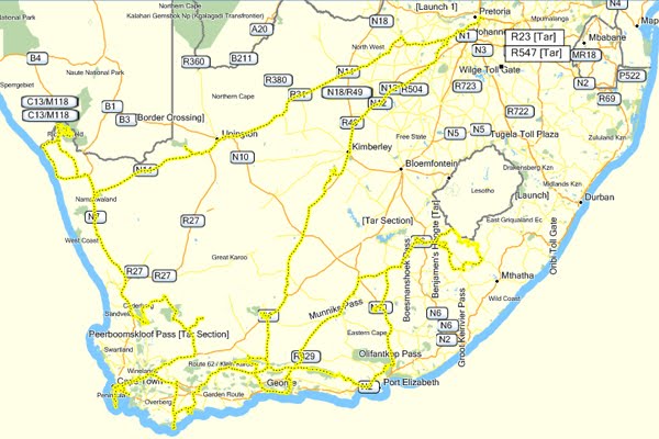
So after a quick stop to pick that up, we headed… To Narnia, and the north! Our mission was to avoid toll roads. This meant that it took us about an hour and a half longer to reach Mapungubwe National park, but cost us more than R200 less. This park is the sight of the Mapungubwe Hill upon which a very famous golden statue was found… More about that just now…

We reached the reception from the western side. After checking in and booking a Herriatge tour for the next day, we had to backtrack some 20km before finding the turn off to the camp site. There is no other way to do this.

The camp site, in National Parks fashion, is really nice! It has an electrified fence around it, but only to keep Elephant out. The rest of the animals will probably fit underneath. The individual camp sites are far enough apart to create a sense of privacy and the central ablution facility is really nice… although not marble.

We cooked a killer Bolognaise and retired to the palatial comforts of our own roof top tent! Neither one of us had slept that well in about a week.

Day 43:
We woke up, well rested, to a fantastically warm morning in the bush! The birds were louder than you can imagine and the lush green bush incredibly inviting! I suddenly realized how much I have come to disliking cities and masses of people.

One quick shower and coffee later and we were in the car and on our last game drive in South Africa. The game in the park is plentiful! We saw masses of Impala, Zebra, Wildebeest, Water buck and some other plains game. The park is split in two by a citrus farm, and when we drove from our side (Vhembe) to the reception side (Dongola), we even saw a breeding herd of Elephant at a water hole right next to the road!

We drove down to the confluence of the Limpopo and Shashe rivers before our tour. The parks people have built an impressive walkway and even more impressive view points on a high rocky hill overlooking the action. We were impressed!

At 10 AM we met our tour guide, Sedrick. Sedrick is a young man with dreadlocked hair and full of jokes, but it quickly became apparent that he new his stuff! The drive to the site is about 20 minutes by Land Rover. At the foot of the Mapungubwe hill is a protected archaeological digging site. This serves as explanation of how old the site is and what tribal activities were likely in the area.

Sederick explained that the place was found by the Van Graan farmers who convinced an old man to tell them were it was after hearing rumours of treasure. They discovered it not much later and their son, who went to the University of Pretoria bragged about it there. The University then did the archaeological thing and basically removed all the artefacts, treasure, and even human remains. They then shipped it back to Pretoria to study it further. This all happened in the 1930’s

They then discovered this to be the first signs of class discrimination in Africa as the king lived on a hill and the commoners down below. Or something like that.

In 2007, after much debate and aggravation, the University allowed the tribes who lay claim to the ancestry to rebury the remains on the hill. There is currently a massive exhibition centre being built on site and the idea is that the rest of the artefacts and treasures will be returned there once completed.

The biggest treasure of all is a tiny golden Rhino. It’s actually a wooden carving that has been gold plated. The university buffs believed this to be evidence of trading between the Middle and Far East and Africa around 1200 AD. Recently it was speculated that the gold may have come from South Africa. That was dismissed by the fact that the first discovery of gold in South Africa was in Baberton in the 1830’s I think. More research and testing found that it actually came from mines in what is now Zimbabwe and even further evidence suggests that the guys from the Middle and Far East came there to get gold, and trade it for glass beads amongst other things. Funny thing here… To this day South Africa still import their glass beads from China.

So in short:
There once was an ancient civilization that lived happily on a hill and discriminated against the poor. The rich ones who died got buried there with some gold. The farmers came to take the gold, but then the university took it, and the human remains. Now they’re giving it all back, including the Rhino, I assume.

The cost of the tour is R135 per person and it is well worth it!

We left the park after a well derived sandwich made by Catt. No one makes sandwiches better that she does, by the way! Our next and final destination in South Africa was Musina and we reached that shortly after. I had to close a bank account, Catt wanted to Skype with her mom, we needed to get some reflectors and we were done and out of there within half an hour!

That brought is to the chaos known as the Beitbridge border post! The last time I went through there was some 15 years ago and it was utter frustration! That was before Zimbabwe fell to pieces and everyone in it wanted to leave! That was also the last time the place was painted, or cleaned I think.

Touts will try and tell you that you can not do without them, and they will jump the cue for you. However, the process is simple enough: On the South Africa side you do your immigration first. When leaving SA you can jump the half a kilometre long cue and go the counter of the far right hand side. Then you do customs. You need to declare your camping equipment and camera equipment and pretty much everything apart from food and clothing. Then you do a Police clearance where you get asked for a cold drink. (We did not have cold drink to offer) and then you get to the bridge. This is where we were told that we did not have the right declaration form and we got sent back to find the right one. ( I suspected that if we had cold drink, this may have been avoided) Once we had that right declaration form, we were allowed to leave the country without the guard reading even the first line of the form.

Now the Zimbabwe side. More touts will try and sell their services. The immigration is quick and easy and we did not even have time to fill in our forms while standing in the cue. Catt had to get a visa because they don’t like the English, but even that was an effortless $55 to spend. I had to pay for the bridge toll, another $9.13 without problems. Then came customs. The touts kept on jumping the cue and kept on pestering me to use them. I simply refused and by the time I eventually got the front, the friendly lady looked our paperwork over, stamped all that was needed and sold us the compulsory 3rd party insurance at $70. She was smiling while she took our money though.

Top tip here: They quote everything in South African Rand. If you pay in US$, they exchange at 10 to 1. So our insurance of R700 should have been $94 according to the R7.50 per $ we exchanged at. However, they only charged us $70 for the R700 insurance.

After customs you get another Police clearance and then a customs inspection before getting the final stamp to leave the border post. Half way up the ramp you hand over your gate pass to a Police man asking for a Coca Cola (Which we did not have for the second time) who tears it in half and at the top of the ramp another person takes the remaining half and opens the gate to Zimbabwe to you.

So, a total of $134.13 (ZERO bribes) and two hours later, we hit the road again. We had decided to stay at the Lion and Elephant motel at the Bubi River that night. We arrived a shade after 5 and immediately realized that it was a great decision! The only change to this place since my last visit 15 years before was the size and magnificence of the massive Bougainvillea plants at the entrance. The friendly owner charged us R50 for camping and even offered to supply us with meat for our journey on.

While pitching camp we came to a sudden realization that we did break the law! It seemed as if we had smuggled some wildlife in from South Africa. When Catt lifted the rain cover of the tent, she found a fruit bat that took refuge there. The poor fellow obviously mistook it for a safe place. He could only have come from Mapungubwe and he must have spent a terrible day in the dark visiting border posts and getting bounced around under the cover. We were however parked next to a Paw-Paw orchard and started hearing the sounds of other fruit bats just after sunset. He must have made a friend as he was gone by the time we went to bed.

We were alone in the simple camp site that night… The way we prefer Africa! It was slightly emotional to leave South Africa, knowing that it will be long before we return, but this was where our true African adventure started!

If I had to do it over again:
I would have liked to spend less time in Pretoria and more time in Mapungubwe. This was simply not possible due to the amount of people who wanted to see us and we wanted to see, and the amount of admin we had to do.

If Botswana was on our itinerary I would have crossed over at Pont Drtift and then Plumtree, or even Pandamatenga into Zimbabwe. This would have cost us too much money though which is why we selected to brave Beitbridge.

Stats:
We travelled 9 400km over 43 days in South Africa and spent R15 000 on fuel. We spent R4 500 on accommodation and R7 000 on food. After car fixing and buying a few more bits of equipment we are over budget, but only by about 10%. We plan to rectify that by buying fruit and vegetables in markets and staying in places like the Lion and elephant at R50 a night!

5: Aliwal North - Bloemhof Dam (South Africa)


South Africa Pictures Here:

Day 29:
Our humble bush camp beside the Orange River made us a little lazy and slow in the morning. The owners of the camp site managed to create an atmosphere of peace and tranquillity and the rustic, piping hot shower was another welcome treat to a chilly Freestate morning.

On the way into Aliwal North we stopped at a magnificent steel structure bridge and after fuelling and watching the rest of the gang shop a little we turned the noses of the vehicles south and headed from the town of Cradock, home of the Mountain Zebra National Park.

I’ve driven through Cradock many times and have often threatened to go into the park, but somehow never had the time. It is also far enough away from where we used to live, that we never made a trip to go there specifically. I have to say that, on arriving in time for lunch, I was very pleasantly surprised.

The beautifully lawned campsite is nestled in-between high hills on three sides and has very well kept facilities. It has shady trees under which to hide from the sun and a friendly and welcoming atmosphere. Outside camp you will find a circular route you can drive of about two hours or so which takes you to the top of the plateau. On the day we arrived there were some stormy clouds around and it was very cold on the top, but the game viewing was exceptional and the light conditions better than any photographer could ever wish for!

After spotting vast herds of Black Wildebeest, Mountain Zebra, Blesbok and Eland, we even saw a couple of Buffalo and a few Meerkats scurrying around in an open field. We managed to avoid all the rain clouds and arrived back to a very wet campground in time to pitch camp, light a fire and pour a drink before dark.

Day 30:
The first day I wished we were not travelling according to someone else’s schedule. We got up early to go for a drive with the plan of re-joining the group at 9 am, our planned departure time from the park. The morning game drive was even better than the previous afternoon and I could have spent another two or three hours comfortably, up on the plateau. The light conditions were brilliantly warm and the photographic opportunities were plentiful!

We none the less made it back to camp to leave with the group and headed off to Addo Elephant Park close to Port Elizabeth. Incidentally finding out that Port Elizabeth is a little further south than Cape Town… Who would have thought?

I had been to Addo once before and was excited about exploring the park again. It is vastly different to the kind of game areas we had been to before. The vegetation is mostly “Spekboom” (Portulacaria Affra) and provides nutrition for herds of Elephant, as the name suggests, but also the densest population of Kudu I have ever experienced! The scenery is phenomenal from the high viewpoints and you can even see the ocean. Addo boasts that it is the only national park that protects the big 7: Elephant, Buffalo, Rhino (black, not white), Lion, Leopard, southern Wright Whale and Great White Shark. On our afternoon drive we managed to spot a few Elephant, a lone Buffalo, plenty of Warthog and an incredible amount of Kudu. Their bodies were smaller than the Kudus I am used to seeing further north in the country, but the horns had nothing to be ashamed of!

The camp itself really impressed me. It had the same friendly and welcoming atmosphere as the place we stayed in the Cedarberg, Sandrif. Every sight was covered on three sides by strategically planted Spekboom shrubs and the ground was covered with gravel. This all ensured a clean, easy and efficient location to park Magurudumu and pitch our trusty roof top tent. The ablutions, as per National Parks board standard were neat and clean with plenty of hot water for comfortable showering in the morning.

Day 31:
The leaving time was set as 8 am by the tour leader as we were due to attend a lecture on the Baviaans Kloof Nature Reserve’s history, fauna and flora. Unfortunately the volunteer who was supposed to give the lecture could no longer make it, which, to the female companion’s delight meant a longer stop over and shopping expedition in the town of Patensie, lying on the one side of the Baviaans Kloof.

The road there meandered through the Eastern Cape and over some beautiful mountainous vistas. The distance was not far, so we arrived at the Tollbos shop on the edge of town promptly before 11 am. It was unanimously decided that now was a good time for tea and cake, or brunch for the more hungry. The shop/restaurant is a place not to be missed. Even though the staff could not tell us where the town’s name stems from, it is packed with home made jams, sauces, marmalade and mampoer (Strong home brewed liquor)

On the journey out of town, while waiting for some of the group to refuel, a slightly plump middle aged man on a small motorbike stopped next to my window to say “Good Morning”, more as a pronouncement than a greeting. We chatted for a minute or two about the groups plans before he gave explicit instructions for us to stop by his farm just outside of town so he could provide us with Nartjies (Clementine for the poms) We did as instructed, coming to a halt next to the sight boards of “Danie Malan” and by the small motorbike and gleaming face of the man himself. Danie told us that his crop was being picked the next day for export, but no one should enter the Baviaans Kloof without sufficient citrus. We led us into the orchard and insisted on helping us pick the prize fruit hanging from his trees. He proclaimed the name of the specific Nartjie to be “Nova”. Suffice to say that if I ever spot Nova in a shop, I will buy it immediately! Partly because of the taste, but also because of Danie Malan’s generosity, great friendly smile and the fact that he could tell us where the name of Patensie came from: Place where the cattle lie, from the Hottentots language.

Bags full of fruit we set of to the park entrance and shortly after we were engulfed by the high cliffs on either side of the valley. We had arrived in the Baviaans Kloof. It is a strangely eerie place with dark corners and sharp bends in the steep passes. We had a short stop at the impressive and modern information centre before taking on a pass right to the top of the mountain… and our accommodation. It felt very strange to be camping on top of a mountain in a park with “Kloof” in its name. The old building at Bergplaas consisted of two dorm rooms, a bathroom, kitchen and most importantly, a comfortable lounge with fire place in. The wind was icy cold and quite determined, so we welcomed the shelter inside with newly warmed bodies and hearts.

Day 32:
A rest day… Or a non driving day if you prefer. We woke to a fierce wind tucking at the tent flaps and misty clouds rising from the valleys below, called “Valley Release” by paragliders. We welcomed the warmer structure with fireplace out of the wind for morning coffee and by the time the usual morning habits were done with we decided to go for a wander. The weather had seemed to agree as the clouds lifted and the wind subsided and the temperature increased to a comfortable walking environment. There were no hiking trails to speak of, so we followed a faint old track up the closest hill. We lost the trail at some point, circled the top of the hill to find it again, and some 8km later arrived back to the cottage for a well deserved lunch.

After sustenance we lingered in the friendly sunshine for a while before taking a stroll down to the road to a cable way. This was an ingenious way for the old farmer to get his produce to the markets half a day earlier than his competition. Instead of trekking all the way down into the valleys, he simply used the cable cart system to move from hill top to hill top. Clever man!

We arrived back at Bergplaas well before sunset and enjoyed another warm and wind free night in the mountains. We did come to a simple and obvious realization that night: When camping in a forest, expect rain… When camping on a mountain, expect wind… When camping surrounded by woolly sheep, expect cold… I’m pretty sure this is where the “weather rock” method of forecasting comes from.

The weather rock:
Take one rock of any size and hang it on a string from a home built A-frame so that it dangles above the ground. Put a sign up that reads something like this: When the rock is wet, it is raining. When the rock is white, it is snowing. When the rock is hanging at an angle, it is windy. When you can’t see the rock, it is dark. You get the idea?

Day 33:
After thoroughly enjoying a day without driving, it was time to move on. There was a general plan to have lunch at a picnic spot in Meiringspoort. Although we had been there a few days before meeting up with the group it was such a special place that we fully agreed with the plan.

The drive down the mountain was very interesting and often slow. The route meandered through the valley, crossing the river several times before spilling out onto open plains at the end of the Baviaans Kloof. There was a place named “The Key” where one key boulder prevented the cliff on one side from coming down and closing the valley off permanently. A scary thought when driving below it.

We lost the group because of stopping for a herd of Mountain Reedbuck, but had our own lunch in Meiringspoort before moving on to the Karoo National Park, our destination for the day.


This was the second day that was too long for us. We left the mountain top palace of Bergplaas at 8 am and arrived in camp in the Karoo National park just before 4 pm. We still decided to do a circular game drive, not expecting much. It was as expected. I think the Karoo National Park is more about flora than fauna. The scarce game seemed to be skittish and although we did not see too many mammals, the scenery was incredible! The Klipspringer pass ends at the top of a mountain and at a lookout point to a deep, narrow and dark crack between the two mountains.

We arrived back at camp just before dark and were engulfed by the familiar sounds of Parks Board camp sites and the group we had been travelling with. Once again a pleasant camp site and pleasant ambiance.

Day 34:
We had decided the night before not to go for an early morning drive. We got up fairly late and enjoyed the comforts of the camp ground. Departure time was set for 9 am and after fuelling at Beaufort West we headed north, homeward.

Suddenly we were back in national road roadwork and traffic consisting of long distance travellers and trucks. Our aim was to reach Mokala national Park for that evening’s stop over. On the way the group decided to stop for lunch at Kambro Farm Stall on the N12, some 20km north of Britstown. This simple but friendly stall serves a variety of good food and wine which the group indulged in. For us on budgets they provide a nice table and chairs outside the restaurant, complete with resident friendly dogs to keep you company. This place is highly recommended for anyone travelling that route.

We took the scenic route to Mokala and arrived at a closed gate with a radio on a post around mid afternoon. I picked up the microphone and my greeting was instantly answered by reception, explaining that we had to drive some distance into the park to find them.

I have to say that I was very pleasantly surprised by this park and almost sad that we had only discovered it then! It is typical Kalahari bush scenery with Camel Thorn trees, grassy fields and red Kalahari sandy roads. The game was skittish, but plentiful and they boast an impressive mammal and bird list. Amongst other things they list Roan, Buffalo, White and Black Rhino, Caracal and Blue and Black Wildebeest. The bird list is so extensive that I wouldn’t even start to mention the specific species.

The sunset was spectacular in a way that only Kalahari sunsets can be. This time I was ready for it and manage to snap some pictures. I was pleased with the result! In fact, I picked up a brochure of a photo competition run by National Parks to produce a coffee table book of Kalahari parks and decided to enter them into that competition. We’ll see at the end of the year if they think it was a spectacular sunset!

After a fruitful afternoon drive we arrived at the only camp site in the park to meet up with the rest of the group. The camp site itself was small, but adequate with neat and clean facilities. They have a single bungalow to rent which can accommodate four people and about 10 camp sites. There is a water hole right in front of the bungalow, removed from the camp site only by a grassy lawn, but no fences. They also have a boma as an evening retreat which was a welcome shelter from the cool evening breeze.

Day 35:
We woke up early for a change… It’s amazing how birds always wake up half an hour before sunrise. Mokala has many birds! We folded the tent away and jumped into the car and left just as the welcoming golden sun peaked over the horizon. We were treated to sightings of Buffalo early on and plenty of plains game as the morning grew warmer and brighter.

A little ranting…
One thing I absolutely hate about SA National Parks is the amount of “No Entry” signs in their parks. I recognise that parks are there for conservation, not tourism, but surely the tourism is what makes the conservation possible? I noticed on my last visit to Kruger Park that there are more roads you are not allowed to travel than roads that you are. At Mokala they plastered “No Entry” signs all over the place and even on roads that were marked on their map as tourist routes. This made the routes you were allowed to travel very limited indeed. We did the naughty thing and ignored one of those signs to find the road in a terrible state from flood damage and a normal car would not have been able to drive it. However, we never needed to engage 4x4 and we had our best sightings on that road. Surely the park manager could rather put a sign up saying “4x4 only” and allow visitors to see the most of their magnificent park?

Ranting over…

OK, so our morning drive ended back at the camp site and after a very nice and hot shower we had a brunch on the lawn overlooking the waterhole. During lunch we were visited by so many animals, and so many birds that I had to keep the binoculars, camera and bird book next to me at all times. I was very keep to string up a hammock under a Camel Thorn tree and spend an extra day or two without moving!

We had to catch up with the gang though, so headed towards Bloemhof around mid day, braving an unimaginable amount of “start/stop” road works. We were booked in at “Die Hoek” camp site just below the Bloemhof Dam wall. Bloemhof dam in the Vaal River and home to one of the largest water bird populations in South Africa. It is also one of the largest dams in the country and if they open the sluices a fair amount of property gets flooded.

Die Hoek was one of those properties which had to be flooded earlier the year. They had to rebuild their facilities after that, so we expected something modern and nice. Oh boy... were we mistaken! We found a camp which catered for fishermen, complete with stinky, rotten fish smell, horrific ablutions and to top it off, no water. This was due to someone’s septic tank falling onto the municipal water pipe and severing it. I sorely missed the Kalahari sunset of Mokala!

I’m pretty sure this won’t be the worst campsite on our journey and I am pretty sure we will experience much worse facilities that that before long. However, if you need to stop over in Bloemhof for whatever reason… Try somewhere else.

Our group dwindled to 4 vehicles, but we managed a cosy camp fire, a killer Risotto and quality conversation drowned out the negatives long before bed time!

If I had to do it over again:
Well… I think I would have liked to take double the time to see the same places! The tranquillity of Mountain Zebra National Park deserves at least 2 nights, if not 3. They have a hiking trail which we were keen on, but did not have the time.

Addo, although not much to drive, has two parts we did not even venture into. These are both on the coast and have day hikes and overnight hikes which we both though would have been fantastic!

Baviaans Kloof and our mountain top palace was great, but another night or two in the bottom of the valley would have been really nice and would have given us the opportunity to explore the surroundings in more detail.

Karoo National Park’s one night satisfied me. The camp site is really nice, they have a few trails to walk, but I did not feel the need to stay there longer.

Mokala was inspirational and I would have loved to stay there at least three nights, despite the hated “No Entry” signs. It is a young park and can do with our patronage. I expect great things from that place in the near future.

Bloemhof was necessary to avoid an 8 hour driving day, but I’d almost consider braving the 8 hours rather than staying there.

For the week we were the guests of a group who are used to travel together and who has limited time to fit everything in. We appreciated their time limitations and felt that the organizers did a great job of planning a spectacular journey through breathtaking environments. I hope we get the chance to visit these places again and at our own leisure.

4: Victoria Bay - Aliwal North (South Africa)


South Africa Pictures Here:

Week four update:

Day 22:
Funny thing then… Cameras ready for the spectacular sunrise was greeted with torrential downpours just before dawn and a heavily clouded sky. So you will still have to take my word for it!

The clouds did part and the sun did come out in time for us to pack up and move on to our next accommodation. After speaking to a surfer who was camping next to us, and discovering that the sea temperature was an acceptable 20 degrees, we decided to try and make a SCUBA dive in Knysna the next day. Google revealed the existence of a dive operation close to the heads and a phone called confirmed such an existence as well as a willingness to provide us with the necessary air and knowledge needed to make a dive there.

The dive master did say that we could only dive at high tide and that it was subject to conditions. He also said that high tide was at mid day the next day, and we were pleased at the prospect of not having to get up early for diving.

The drive to Knysna along the N2 is always pleasant, even in the rain and upon entering the town we noticed a garage advertising free internet Wi-Fi. We found a suitable camp site in town called Monks and booked in for two nights at a very reasonable R120 per night. (High season rates I noticed were R450 per night.) We quickly set up camp before the next rain came, and after it had passed decided to take a stroll to the garage with the free Wi-Fi. The camp site is right next to the lake and you get a key to a gate opening up onto a walkway on the lake when you stay there.

It was this walkway we took and after half a kilometre decided that the relentless hammering of the wind against us made the slightly less picturesque, but infinitely more pleasant walk along the main street the preferred route. We reached the garage without getting wet, turned two laptops on, connected to the Wi-Fi and the internet… and that is where it stopped! I tried to download QuickTime for the Nettbook for about half an hour and got to about 3% before giving it up as a bad joke and contemplated a hot cup of coffee back at camp.

On the walk back we decided to ask at a shop called the Coffee Connection whether their “hotspot” sign meant free internet, as Catt had thought on the way to the garage, or WI-FI Hotspot that you had to pay for, as I had thought. To my surprise, they did offer free internet and we immediately accepted an invitation to a table and promptly ordered two mugs of their coffee for the day. Almost an hour later I had managed 4% of QuickTime and had not yet been able to download my emails successfully. We paid for the coffee, walked back to camp, fired up the 3G card, downloaded emails, uploaded the website and did everything internet related in about 15 minutes. We did appreciate the walk and the fresh air though.

Day 23:
Our SCUBA diving day… or so we thought. We received an sms from the dive master saying: “All diving cancelled because of last nights rain, bad visibility and strong currents” we looked at each other, sighed, smiled, and went back to sleep happy!

When we eventually awoke, it was a gloriously sunshine day. There was almost no wind, almost no clouds and the temperature was warmer that we had felt for days. It was washing day! We found a laundrette in town who insisted that we did not have to wait for the washing and strolled around the greater Knysna shopping district for an hour before getting bored. We returned to the laundrette in time to read for about 20 minutes before being handed a neatly folded pile of clean clothes and walked back to camp, along the windless lake.

We had planned an afternoon stroll, weather depending, to Thesen Island. This seems to be where the new rich people in Knysna hang out. It used to be the Knysna Heads. Thesen Island’s highest point can’t be higher than 10 feet above sea level and I would personally hate to sleep there in fear of drowning in my sleep. The well planned high street contains more estate agents per square meter than I have ever seen anywhere and there are luxury cars, yachts and boats everywhere you looked! It was designed to look like a harbour town, or village and the designers did this well. It’s very chic and pretty and everything from the cafés and restaurants and art galleries seems perfectly in place! I glanced at one poster in an estate agent’s window and saw a price tag of R16 Million (Roughly £1.5 Million) for a neat little three bedroom semi detached.

We left the island feeling slightly underdressed and wandered over to the yacht club and waterfront. This was definitely more in our range. Many restaurants offering oysters, which Knysna is famous for, at discount prices. There were impressive boats in the moorings and everyday and ordinary people lining the walkways. It was however still absolutely littered with estate agents.

The rain stayed away for the whole day and on the walk back along the wind still lake we stopped to take some “contemplatingly” photographs at an old wooden boat in a make shift dry dock.

Day 24:
It was time to get a move on. The heavy dew from the night soaked the tent and awning, but we packed it all up none the less. We set the nose of Magurudumu north towards the mountains and headed inland. Driving on tar has become a little bit of a bore by now, so we started our journey by way of dirt mountain passes to Avontuur and then using the Prince Alfred pass to get to Uniondale. These seldom used dirt roads wind their way up through indigenous forests and then some plantations to the highest peaks north of Plettenberg Bay before descending into what I assume to be part of the Karoo on the other side. It is an awesomely entertaining drive which does not require any special vehicle and I honestly don’t understand why more people don’t use this route.

Our stop over town was Graaff-Reinet. The guidebooks paint a picture of an affluent farming community and some historically significant buildings and the world’s largest grape vine. We found the municipal camp site, complete with the resident drunks playing loud music despite the stern “NO MUSIC” sign by the gate.

After pitching tents we took an almost compulsory walk into town to see the sights. The impressive church in the centre of town glistened in the afternoon sunlight and the sight did not disappoint! I found it a little strange that a house of God would have locked gates on a Saturday afternoon, but with a manicured lawn like that; I assume they do that to keep people off the grass.

The begging of the hordes of beggars on the streets became so relentless that we made a quick getaway back to the beat coming from the boot of the car of the resident drunk and dived into a serious game of scrabble while there was still light. As if by magic, by the time the scrabble was over, the drunk got quiet, the wind died down and the sun was behind the horizon. We prepared ourselves a feast in a quiet and eerily massive camp ground before retiring to our dry and comfortable bedding inside the tent.

Day 25:
The Graaff-Reinet camp site’s shower heads were bizarrely aggressive. They pointed horizontally and when the taps were open, there was absolutely no way of escaping the lashings from the surprisingly hot drops. Although effective, they were strangely unpleasant and the rest of the ablution blocks reminded me of high school gym class. The ladies ablutions were painted bright pink with luminous yellow behind the doors.

Our route for the day took us further north and inland and higher up into the mountains. We crossed the last parts of the Karoo and ventured into the Eastern Cape by Aliwal North and settled in a camp site called “Karnmelkspruit” some 15km south of Lady Gray. This is where we were to meet up with my parents and some of their friends for their annual touring and 4x4 holidays. From this point on we would become part of a 5 vehicle convoy.

We managed to reach it before lunch, knowing that they would only reach it by late afternoon and contemplated the meaning of us becoming part of those noisy crowds of people we always try to avoid... like the ones we met on our last night at the Richtersberg camp site in week one…

There was one other group in camp and they told us about the phenomenal fly fishing in the river. This excited me greatly as I was convinced that my father would not travel to the Eastern Cape without the necessary fly fishing gear. The gang arrived mid afternoon… without any fly fishing gear, but followed by a lone biker, Jamie, who was at the start of a four month trip around southern Africa. Perhaps we will meet up with him again in Malawi.

The facilities at the camp site were fairly rustic. There was a nice area where we could all squeeze in, not be too noisy and have our first social gathering since leaving home. We discussed the logistics of convoy driving and voiced our concerns about driving slower than anyone else and stopping more often to take photographs. It was all well received and we were asked to lead the group the following day to ensure that we could set the pace. My mom brought us an extra blanket, so we managed a surprisingly comfortable night camping in very low temperatures.

Day 26:
The purpose of the first part of the group’s trip was to drive 8 mountain passes in the Eastern Cape. Much has been written about them recently and everyone was excited about the prospect of seeing the magnificent views for themselves rather than in photographs and magazines.

Our first pass was the Joubert Pass just outside of Lady Grey. It was in fairly good condition and the steep inclines made all the heavily loaded vehicles work hard to the summit. The best view for me was looking back at the town from just before the summit. It always amazes me how fast you can gain altitude in a pass like that. The descent required some fancy gear work and the road settled in a valley meandering through some farm land. I was happy to be driving in front and not having John with his trailer behind me. It was breathtakingly beautiful with the Poplar trees in brilliant yellow autumn colours complimented occasionally by a sandstone farm building with red corrugated roof and rusty gates.

We found a Grey Rhebuck stuck between the jackal proof fences on the road and took the best part of fifteen minutes waiting for it to find a way through the fence before promptly disappearing into a valley. I was a little surprised that they still exist in the area and being a fairly scarce buck to see felt strangely privileged to be able to watch it for a while.

The circular route took us back to the tar road between Lady Grey and Barkley East and after heading south for a while we left tar again towards the Otto Du Plessis Pass, the second planned pass for the day. As leaders of the pack it was also our responsibility to find a suitable lunch spot. This proved quite challenging for a five car convoy. When we’re on our own, we simply need a space the size of Magurudumu and these roads were all in-between private, fenced farms with no trees around at all and no picnic spots. On my father’s recommendation we stopped at the summit of the very wind swept pass. Hiding behind the bulk of the Land Cruiser and overlooking what seemed to be the whole of the Eastern Cape we spoilt ourselves with the last of our Ostrich pate and three cheeses.

The southern side of the pass had very steep down hills requiring low gears complete with a few spectacularly big rocks that had come dislodged from the hill side. At one point we came upon a cow and three calves stuck on the road between a sheer cliff and a sheer drop. Between my father and I, who was driving behind us, we managed to herd them down the hill and off the road using the vehicles.

Once we were down in the valley again the road winded its way through picturesque farmland and mountain streams all the way to the small town of Elliot, our destination for the evening. We popped into the local Spar for supplies to my great surprise found a very well stocked fly fishing cupboard complete with the exact rod I have been looking for, for ages!

It’s a 5 weight rod that comes in four parts and the kit even had a floating line and reel. It was a no brainer at the price, so I paid it immediately and got a little excited about trying it out that day as we were camping by the Thompson Dam which apparently had Bass in.

We arrived in convoy at the dam camp site and discovered with horror that the state of their ablution facilities were utterly disgusting and completely unacceptable despite the assurances of the lady where the booking was made. To be fair, the cost of camping there was only R6 per person per night, so we were not completely taken by surprised. It belongs to the town council and I did phone them to ask for the cleaners to be sent, but that obviously did not happen. I’m sure they also have picnic spots with dustbins that never get emptied.

Ablutions aside, the setting was incredibly beautiful and although there was no biting on the flies I expertly casted into the water, I enjoyed the activity and the place a lot. The sunset was spectacular with a few clouds, a mirror reflection on the dam and autumn colours in the hills. I suddenly had to pick up the rod, run back to the car and grab a camera to take some photos. As fly fishing seem to go hand in hand with good photographic conditions, I should really have taken the camera with me in the first place… So we learn.

Day 27:
We woke up from the bray of Zebra standing no further than 100 meters from our sunbathed tent. It was a glorious morning in the Eastern Cape and the excitement in the group was growing steadily with the prospect of driving three passes for the day.

First on the list was the Barkley pass. Although a tar road, it zigzags through glorious sand stone formations and provides the access to the turn of to the Bastervoetpad Pass, the second for the day. We elected not to lead again and found it a little challenging to keep the pace of the group until we left the tar.

The Bastervoetpad pass was amazing! The climb to the summit is steep and steady and passes through farms with pretty dwellings. The summit itself offers the most breathtaking panoramic view imaginable! It was a lot less windy than the day before and we lingered at the top admiring nature, spotting a pair of endangered Black Eagles and feeling a little small in the vast expanse which lay before us.

Through all the passes I was astonished to see the amount of abandoned houses and buildings. It seems like every farmer simply decided to move out of the original sand stone farm house in favour of a newer, more modern dwelling. It is such a shame to see so much wasted accommodation in a country with so many homeless people.

Driving down towards Maclear was very interesting! The road can best be described as “slow and rough” The first part descends so quickly that I often used my lowest gear to slow us down and manage the rocky obstacles. We were overtaken by a motorcyclist who obviously did not have the same issues. We criss-crossed a brilliantly clear mountain stream, passed a few rickety dwellings, some cattle and drove past spectacular sand stone cliffs on either side of the road. Once we were down in the valley we passed through some pine plantations with the light dancing in-between the trees. We found a random bath in the middle of the field which I wanted to go and pose in, for the photo only to discover that it was being used as a water trough for livestock…

After a quick bite by the roadside we passed through the village of Maclear, left the tar road again and started making our way up to the Naude’s Neck Pass between Maclear and Rhodes, our destination for the evening. The snaking dirt roads towards the Neck of the Naude brothers suited Magurudumu and our driving style perfectly. By this time we selected to be at the back of the convoy and told the group not to wait for us.

The Naude brothers apparently farmed on either side of this mountain and completed this pass in 1911 to enable them to visit each other easily. I found it almost ridiculous to imagine the mammoth task of carving a road so steep and so long even with today’s techniques and equipment, not even considering what it must have been like in 1911!

By this time we have come to realize that every uphill eventually has a downhill and this downhill took us through the Afro Alpine environment on the tops of the mountains all the way down into the National Monument which is the town of Rhodes. The bulk of the group were booked into an Inn for the nights, but we selected the municipal camp site for our accommodation. In great contrast to the camp site at Elliot, this was a tiny camp site with clean and neat facilities in the middle of town. Rhodes itself reminded me very much of a farming village in the Yorkshire Dales. We were told that it is permanently inhabited by about 25 souls only, and when taking your dog for a walk, every dog in the village will eventually join the group and find its way home when walking time is over.

We decided to prepare our own dinner rather than eating a set menu at the Inn and were still feasting on our Cobb made chocolate cake when my parents returned to the camp site after their dinner with the group. My dad presented me with a fishing permit for a dam called “Lochness”. Our plan was to leave earlier than the group and then wait for them by the dam.

Day 28:
It was a cloudy and chilly start to the day. We had a beautiful English Pointer wander into camp and felt it safe to give him some attention. A habit that we both realize will have to stop once we leave South Africa. We packed up camp and left an hour before the rest of the gang.

Within half an hour of leaving town we found a sign which read: “Engage lowest gear, keep revs up, take corners wide, drive confidently” It was sound advice! We had arrived at the bottom of the Carlislehoek Pass and the road to South Africa’s only ski resort, Tiffendell. It took every one of the horses in the 4.2l engine to haul the weight and bulk of Magurudumu up that hill however it is worth mentioning that we were still on 2 wheel drive, so we had Low Range in reserve if needed.

Lochness was described on the map as Tiffendell Dam, and is a gorgeous dam high up in the mountains. The pleasantly cool mountain air made the trout active and I could see them feeding of the surface of the water. I was very excited! While Catt was making friends with the local herd of cattle and taking some photos I was casting away and disappointingly watching some trout jumping over my bait favouring some local insect floating on the water rather than anything I had in my fly box.

The rest of the gang caught up with us after confirming the rumour that Tiffendell went bust and are currently in receivership. Still fishless, but watching the trout rise all around me, I conceded that I did not have the right fly for the job, packed up and followed the group to the top of the mountain and down the other side using the Bidstone Pass.

I don’t think the Bidstone Pass is as steep as the Carlislehoek Pass, but you still won’t want to rely on your brakes to maintain the snail’s pace needed to negotiate the sharp bends and keep away from the sheer drops. It winds down into a valley far below and another gorgeous old farm house in sand stone with Poplar trees lining the road. I was by no means used to the beauty of it, nor was I getting bored with seeing it so often.

Our last pass for the day was the Lundean’s Neck Pass. Unfortunately the weather had turned quite foul. What I would think would be an environment full of colour and contrast and perfect for the avid landscape photographer was cold, dark, dull and windy. The road itself was not uninteresting to drive and the view from the top was still spectacular despite the weather. We found this brilliant little Sheppard’s hut built from stone right at top which made a welcome foreground to a few photographs.

Our journey took us along the Tele River to the Tele border post between South Africa and Lesotho. Still a dirt road, it was littered with potholes, but also with people fixing the potholes using gravel and dirt from next to the road. We joined the tar right by the border post and made good time towards the town of Aliwal North and our accommodation on a guest farm some 20km outside of town.

The farm’s name is Badfontein and we can highly recommend it! The small camp site started as their bush camp and has great facilities including piping hot water, reed fenced ablutions and a neat boma where everyone could sit comfortably and prepare a well deserved dinner after the second long day’s driving in a row.

If I had to do it all again:

It would have been nice to SCUBA in Knysna, but weather is not really something you could change. The drive up to meet up with the group was an unavoidable bore, so nothing to change there.

I would have loved to have fly-fishing gear at Karnmelkspruit, but with my newly acquired toys, that will not be a problem again.

Now the passes.. Day one was fair in terms of driving distance, pace and time. Day two was too long for me! I would have liked to stay on a guest farm between Maclear and Rhodes. I spotted a sign for something called Elands Heights on the top of the mountain. I still would have stayed at Rhodes a night because of the quaintness of it and just use the easy day to relax, perhaps go for a wander in the hills. Day three was also too long for me, but not by much. One idea would be to stay at Karnmelkspruit again, making the day about an hour shorter. I didn’t really spot other options at the preferred time or distance. I’m glad we found Badfontein though as it is such a nice place.

As for group driving and touring… This must be the easiest group to travel with as everyone, despite their vastly different personalities seem to be able to co-exist without any issues. We still prefer to travel alone, but if we had to do the group thing, this group would be our first choice.

For the record, we drove 11 mountain passes, including the 8 of which much has been written. They are, in order of travel: Joubert Pass, Grondnek Pass, Otto du Plessis Pass,
Barkley Pass, Bastervoetpad Pass, Potrivier Pass, Naude’s Neck Pass, Carlislehoek Pass, Bidstone Pass, Lundean’s Neck Pass and Dulcies Nek Pass.